Ocean Current and Tides
Ocean currents play a significant role in the experiences of scuba divers, particularly around Phuket island. Understanding what ocean currents are and how they manifest in this region is essential for a successful dive. At Aloha Diving, our team possesses extensive knowledge about the ocean and its currents. As Scuba Diving Instructors and passionate seafarers, we cherish every moment spent on the water before, between, and after each dive.
So, what exactly is an ocean current?
An ocean current refers to the continuous and directed movement of seawater, influenced by various forces such as wind, the Coriolis effect, breaking waves, cabling, and temperature and salinity differences. Factors like depth contours, shoreline configurations, and interactions with other currents contribute to the direction and strength of a current. Ocean currents primarily involve horizontal water movements, although tides mostly generate these currents at our dive sites.
Understanding the relationship between ocean currents and tides is crucial.
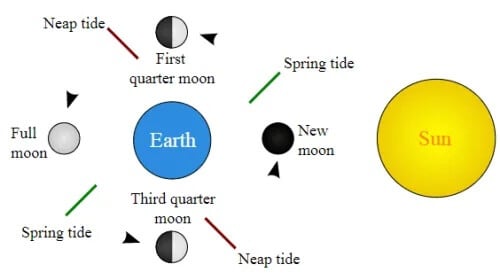
The primary causes of tides are the gravitational pull of the moon and sun. As divers, we experience a strong current during spring tides, which occur every 14 days when the gravitational pull from the moon and sun align. Conversely, neap tides, happening also every 14 days, bring the weakest currents when the gravitational pull from the moon and sun is at tight angles to each other. A full moon cycle spans 28 days. In Phuket, the tidal mean range is around 3 meters, which is considered a moderate spring range compared to the largest tide range of 13 meters found in Canada’s Bay of Fundy.
Spring Tides:
During spring tides, when the gravitational pull from the moon and sun are in line, we experience high high waters and low low waters.
Neap Tides:
When the gravitational pull from the moon and sun are at tight angles to each other, we experience low high waters and high low waters.
For those interested in further exploration, we recommend taking specialized courses such as drift diver, padi divemaster, or one of our boating courses. Tide charts, published by the Royal Thai Navy in Thailand, provide valuable information on tidal movements, and there are also helpful apps available for tracking tides. When selecting a dive site, our primary source of information is an app that displays the tidal movements.
Now, let’s delve into how to interpret tide charts and tide graphs.
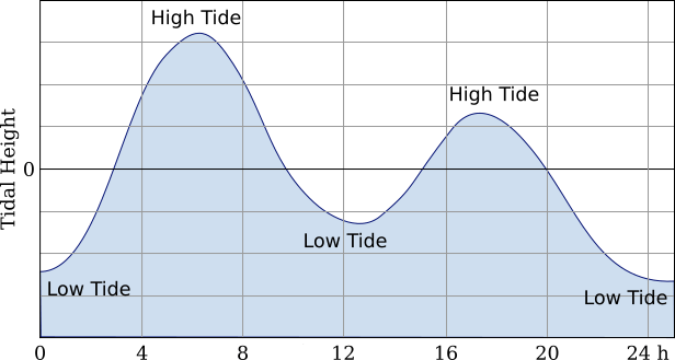
Ideally, we would choose to dive only during high tide or low tide. To avoid confusion, we always start our scuba diving day trips at the same time. However, we must carefully select the dive sites and timing for our dives. To determine the strength of the current, we examine the number of hours into the tidal cycle we are.
For example, let’s plan a dive together on May 7th at 10:20. What can we expect in terms of current strength during this dive?

The provided tide chart displays the water height, indicated by the red circled figure. The greater the difference to the next hour, the stronger the current. In this case, high tide occurs between 8 am and 9 am, while low tide takes place between 2 pm and 3 pm.
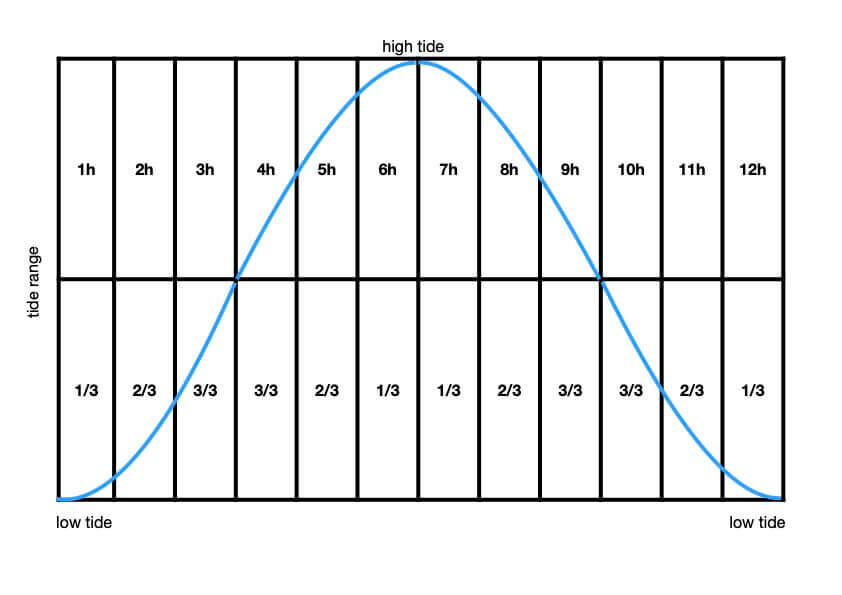
One hour (9 am) after high tide, the water level decreases by 1/3 (0.1 meter) of the tidal height for that day, which is 1.3 meters in our example. Two hours (10 am) after high tide, the water level lowers by 2/3 (0.21 meter). Three hours (11 am) after high tide, the water level lowers by 3/3 (0.32 meter). Four hours (12 pm) after high tide, the water level still lowers by 3/3 (0.32 meter). Five hours (1 pm) after high tide, the water level decreases by 2/3 (0.21 meter). Six hours (2 pm) after high tide, the water level decreases by 1/3 (0.1 meter), indicating low tide.
Now we know that at the planned dive time, the water level will have dropped by 0.21 meters. As the dive progresses, the water level will decrease even faster, assuming a dive time of one hour. This will result in a mild to moderate current.
But how do we determine if a current is too strong?
We classify a tide change of 0.1–0.2 meters as a mild current, 0.3–0.4 meters as a moderate current, and 0.5–0.7 meters as a strong current.
To identify the direction of the current flow, we refer to marine charts.
Here are the ocean current directions in our diving grounds:
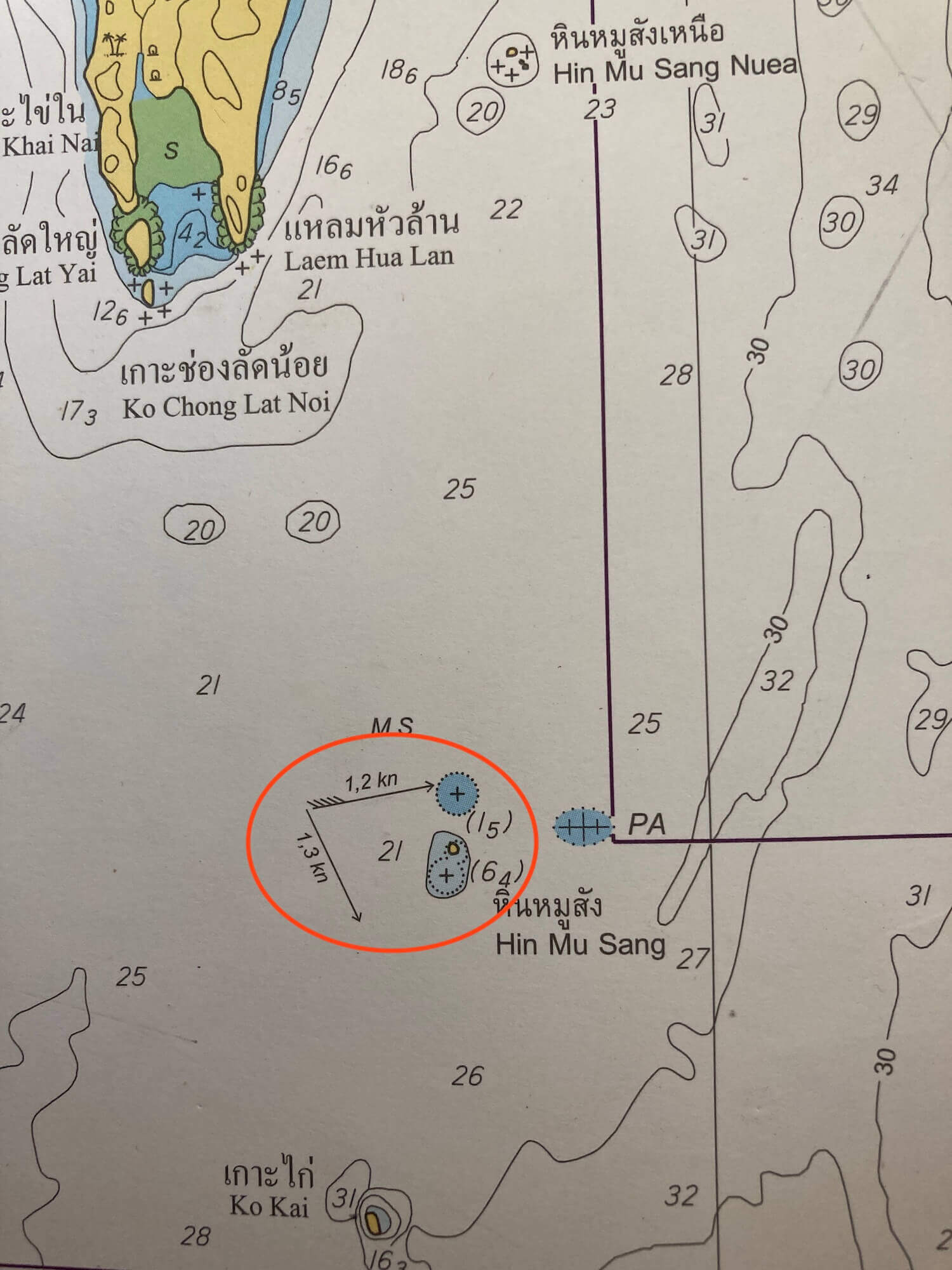
At Shark Point (Hin Musang), Anemone Reef, and the King Cruiser shipwreck, the current flows towards east-northeast during high tide and south-southeast during low tide.
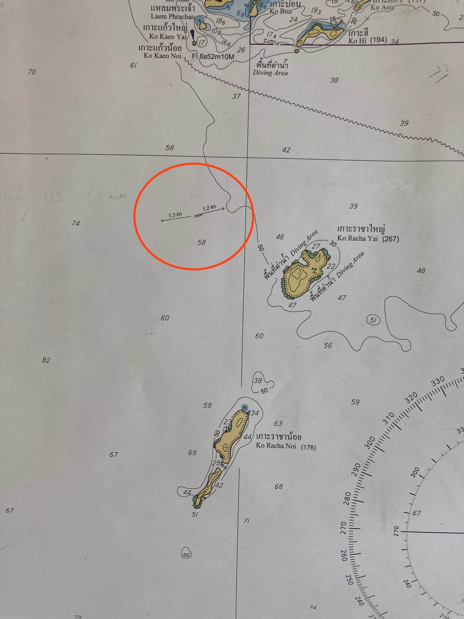
At the Racha Islands, the current flows towards east-northeast during high tide and west during low tide.

Around Koh Mai Thon and Koh Doc Mai, the current flows north to south. During high tide, the current flows north, while during low tide, it flows south.
Having knowledge of ocean currents is crucial for a safe and enjoyable dive. As divers, we often aim to utilize the current to our advantage by “going with the flow.” However, there are instances where swimming against the current can be beneficial. Effectively navigating against the current is a topic covered in specialized courses for divers experienced in handling currents.
When selecting the best dive site, it’s also important to consider factors such as wind and sea state.
By considering all these factors, we can make informed decisions to ensure memorable and safe diving experiences.


